Coast to Coast – Day 10

Egton Bridge to Robin Hood’s Bay – 17.5 miles

After a restful night and a fabulous breakfast we were soon in the waiting taxi and heading to Grosmont. The weather this morning was overcast yet the forecast was for a dry day with occasional showers. At Grosmont we purchased our packed lunches from the Co-op and Lynn went off taking pictures of the steam train in the station. Whilst taking our final look around we saw two Australians and later saw Kitti who had not long had breakfast. Soon we were on our way but there was one last sting in the tail, a long climb (700 ft) out of the village.

As we were leaving there was a lot of activity with vehicles heading in towards Grosmont. We had seen on posters that the Egton Agricultural Show was on today, hence all the traffic heading towards us as we were climbing the hill. As had been our luck the views we have had when climbing have been fabulous, with no exception today.

At the top of the two mile climb the wind became stronger; we were now on Sleights Moor. The sun began to shine and Whitby Abbey came into view. Crossing the moor we arrived at the A169 road

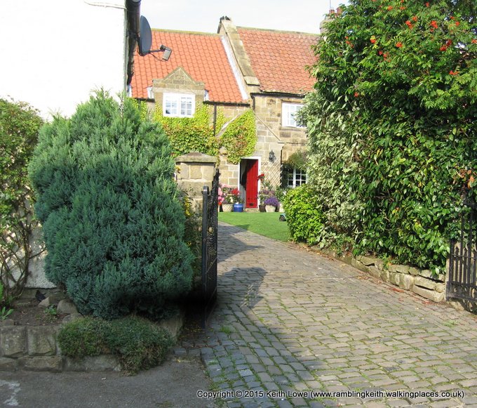
to Whitby and just after a short walk along the road we followed the path to Littlebeck. As we walked through the village

we found a bench where we had a coffee stop and a check on our location.

Break over, we entered Little Beck Wood. Following the path was quite picturesque but, as with most woods when there is no sun beaming through the trees, the ground can become very muddy-and it was! According to guide books the

woods are filled with deer, badgers, foxes and birdlife; we heard the birds but saw no wildlife. As we trudged through the woods trying to avoid the mud, and the slipping & sliding when near streams, we came across a cave.

We peered in but there was nothing to see, so we continued our walk. About an hour later further into the wood and walking up the long steep incline, we came across a hermit’s cave.

Just across the path at what looked like a walled balcony area looking down into the woods two people were resting after their ascent. Examining the cave, which was just a boulder hollowed out and a date of 1790 above the doorway, we asked the couple what was its purpose but they didn’t know. After a brief respite we continued

and now we could hear people at the waterfall below, a local beauty spot with tea gardens etc. We stayed on the higher ground to avoid the crowds till eventually we arrived at the car park at the other end of the wood. By now it was time for food; the good thing was that the sun was shining. We found a quiet spot, boots off and had lunch whilst watching the hordes arriving.

After refreshments it was a steady uphill climb with very impressive views. We were looking for the sign post to Sneaton Low Moor which could easily be missed as it’s right on a bend of the road. On the moor there was more than one path but fortunately in the distance we could see a way post and ahead were two other walkers, so this helped. Once finally across the moor we arrived at the B1416 road, staying on this for a short while before heading over Graystone Hills (moor) which turned out to be a little boggy,

but manageable. Crossing the A171 road we saw our first signpost to Low Hawsker, an indication we were getting closer to the end. As we entered the continuation of the moor two people were flying kites with their children and the one child asked his mother if we were explorers to which we replied, “Yes.” Walking across the rest of the moor we had a clear view of the North Sea and

at times Whitby Abbey again, but now the abbey was encircled with direct sunlight

whilst the surrounding area in shade. We continued along the moor till we reached Rigg Farm, and were on a tarmac road to Low Hawsker when we saw the first sign to Robin Hood’s Bay.

Staying on the road for a while we were heading for High Hawsker and passed several caravan parks, some with awesome views of the North Sea. According to our guide book there was a tea room at Northcliffe Holiday Park, so as we had been walking for some time we thought it would be a suitable stopping place. Unfortunately, we eventually arrived at the holiday park only to find the tea room was closed. Further along the road was a sign for the C2C path pointing down to the coastline. We followed the path through the holiday park where we found a small seating area overlooking the sea, so we finished off our flasks of coffee/drinking chocolate.

After the break we headed down

to the coastal path which now had signs for the C2C and Cleveland Way.

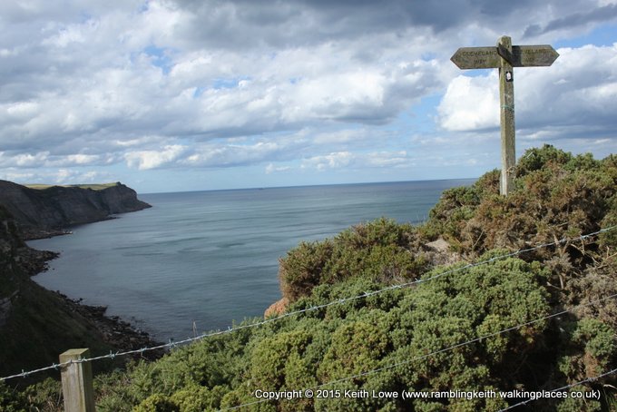
The route was easy to follow, we just needed to remember to keep the sea on our left. As we walked, Lynn & Steve started their singing ’Funiculi, Funincula’ with the occasional conversation in broken Italian which was quite hilarious. During some quiet moments we took more photos

Continuing along the path,we passed the coastguard station and the Rocket Post Field where coastguards used to practise aiming their rescue rockets ready for when they needed to reach ships stranded off this treacherous stretch of coast and bring people back on dry land.

We arrived at a point where we could see Robin Hood’s Bay in the distance

and followed the path until eventually we came to the village.

We arrived at around 5pm in blazing sunshine – what a fitting end to a super adventure! Now we need to find our accommodation (The Villa) which was

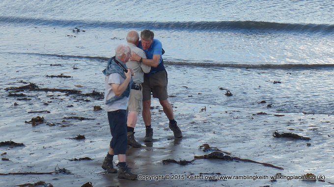
easy to locate as it was on the main road down to the sea. We checked in as requested by our host then headed down the steep hill to the water’s edge

for the customary dipping of our boots and throwing of stones, brought all the way from the St Bees to Robin Hood’s Bay (192 miles), into the sea. Down on the beach Steve accosted a passerby to take our photo,

which was then followed by the obligatary man hug.

Whilst these rituals were going on fellow walkers in the Wainwright’s Bar were cheering us on so we ventured up to meet them. Before that we still had time for another photo outside the pub by the finish sign but in doing so we had to disturb the people already there drinking.

Clutching our celebratory drinks we went out onto the hotel balcony where we met up with some fellow walkers.

A couple from Australia.

The Manchester couple who backpacked.

After a most pleasant drink and chat we set off back to our B&B to freshen up, but not before finding somewhere to eat that night and booking into the Smugglers Restaurant.

At ‘The Villa’ we were met again by our host who was wanting to sort out breakfast arrangements, which we did fairly quickly. Then a freshen up ready to paint the town red. (So to speak)

We headed off to the Smugglers Restaurant and were on our way down that steep hill for the second time today when we saw Tracey

& Kitti.

They were sitting outside the cafe’ half way down the hill and had just arrived. Whilst chatting we were asked to sing ‘Alouette’ as they thought it was so funny the first time they heard it. Steve & I were mumbling the French verses that Lynn sang properly; it must have looked and sounded like we had a mouth full of wasps. Needless to say we received some strange looks from passers-by. Asking if they were booked into their B&B, Kitti said she thought it would be wise to clean her feet first.

…….Phew!!!!

We left them to go down to the sea to take part in the customary stone throwing whilst we had a drink before having our last meal of the walk.

The restaurant was very busy and we couldn’t resist the traditional local seafood chowder to finish the evening before heading back to our accommodation.

Coast to Coast – Day 9

Blakey to Egton Bridge – 12 miles

We thought we were up early yet as we went for breakfast a couple of Australians were just leaving their table (this was one of the two couples from yesterday).

Wishing them a safe walk they were then off. After breakfast our host took us back to the start point of the day, on top of the moor.

The winds were quite strong yet the sun shone. We said our goodbyes and set off across the moor. The good thing now about the C2C was that it was literally all downhill according to the map profile. We are walking to the Esk Valley heading towards Glaisdale and the area we were about to cross was used in the TV programme ‘Heartbeat’. The walk began at Young Ralph Cross, a stump sticking out of the ground. We passed the landmark of Fat Betty (one of two wheelheads on the North York moors) then followed the trail past Trough House which is a shooting box/ refuge for those involved with grouse shooting.

Leading to Great Fryup Dale

the path was easy to follow with plenty of C2C signposts and there was no need for a map as the weather had become clear & sunny. The views were very impressive with light purple heather for as far as the eye could see

and in the distance the North Sea was occasionally sighted. We were now developing a sense of achievement as the finish was only a day away.

As we were nearing the end of Glaisdale Rigg it was time for a break, so we found a secluded spot and sat drinking our coffee in the sun. Everything was tickety boo.

After our break we soon reached the end of Danby Moor

were now back into civilisation as we had arrived at Glaisdale.

As we walked down into the village we met up with the young couple from Manchester. They were buying the next day’s breakfast before going to seek a campsite for the night. We wished them luck and headed on to find Beggar’s Bridge.

The Beggar’s Bridge story is that in the 17th century a pauper name Thomas Ferris was courting the daughter of a wealthy squire. In order to win her hand he needed to improve his status, so he planned to set sail from Whitby to make his fortune at sea. He went to the river to say farewell to his sweetheart who lived on the other side, but the river was in flood. His dream of a romantic farewell was shattered, but he did make his fortune at sea, returned and married the women he loved. With part of his wealth he built the bridge so that no other young lovers in the village would be separated as they were.

Just next to Beggar’s Bridge is new bridge supporting the British Rail mainline to the north. Under the bridge and over the ford we were now entering a small wood which also followed the River Esk. In some sections it was very muddy so extra care was needed. Turning left out of the wood the map was showing us there was a bench alongside the road, so it was time for boots off, air the feet and have lunch. At this point we knew we were close to Egton Bridge. As we had lunch several walkers past with a cheery, “Hello”. Suitably rested, it was boots on and then a little bit of road walking to Egton Bridge. As we arrived we saw the Horseshoe Hotel

so Steve went to reserve a table for the evening. Next it was on to locate Broom House, our accommdation. We found the bridge

(very picturesque) next to some stepping stones

and, following the guide book, we crossed to discover our accommodation about 15 minutes walk from the Horseshoe Hotel. At Broom House

we were met by our hosts, shown to our rooms, (again I was on the top floor) then told of the house rules.

We decided that as we had time today we would walk on to Grosmount as Lynn is a steam train enthusiast. We contiued about two miles, passing other walkers, and arrived in Grosmount

where Steve and I sat awhile whilst Lynn took photos.

We eventually ended up in the engine sheds to look around before sitting down to a refreshing cup of tea and a scone.

We now faced a dilemma. Should we walk back to our B&B which would mean that we would have done more miles than the full 192 miles of the Coast 2 Coast and would still have to walk back to Grosmont in the morning or, as we had finished the days walk in Grosmount, not Egton Bridge, should we arrange a taxi to take us to and from our B&B? After a brief discussion we decided on a taxi, which we duly arranged to take us to Grosmount in the morning.

Back at our accommdation, we asked our hosts we asked about the best way to the Horseshoe Hotel that evening. They suggested the stepping stones and to help us on our return they provided us with torches (how thoughtful). Without further ado we set off for dinner and returned safely, no wet feet nor anyone falling in the river. Phew!!! Then it was time for sleep ready for the final day.

Coast to Coast – Day 8

Great Broughton to Blakey – 8.5 miles

Following a restful night and a hearty breakfast we needed to be taken to our meeting point of yesterday but, as there were so many walkers in the same situation, we had to wait before being transferred to the start of our walk, Clay Bank Top.

It was onwards and upwards for the penultimate climb up to Urra Moor. As we climbed the clouds were low, hiding some of the tops of the hills

in the distance but by the time we reached the summit the clouds had disappeared.

We came upon a walker sitting & eating,

it turns out he’d spent the night on top of the moor and was now having breakfast. Our path unrolled across the heather clad moor

with fantastic views again and the weather was improving all the time.

In the distance we could see other walkers and as we caught up with them whilst they were having a break we found out they were practising for the Duke of Edinburgh Award Scheme. We continued until it was time for our first break of the day. It was probably not the best place to stop as when we settled down we were inundated with either midges or very small flies, so it was only a short stoppage.

As we set off again it wasn’t long before we caught up with two Australians we had met previously in Reeth and, as we walked, we chatted generally about one another’s walking experiences and countries. We were now going along the old Rosedale Ironstone Railway which is at the height of 1,200 feet and served the nearby iron mines nearly two centries ago. For me the path was a little uninteresting, but easy on the feet and still having awesome views. At a cross over of tracks we stopped to take pictures

and the Australians walked on.

We set off and could hear grouse in the distance, reminding us it was the grouse shooting season, but luckily there was no shooting on this moor. We were walking quietly when Lynn actually spotted a grouse up ahead on the path. We had cameras at the ready and just crept as near as we could before it flew off.

Our first close up of wild life, brilliant! We were now walking along Farndale Moor leading to High Blakey Moor where the path divided, our turning looking towards Helmsley & Kirkbymoorside.

Now it was a short climb to the Lion Inn where our next pick up point was. We arrived at the inn and saw the two Australian couples again. They were having lunch and in the field opposite was a young couple from Manchester we’d also previously met who were camping for the whole of the journey.

We spoke to the Mancunians as we hadn’t seen them since they left Marske, on the Reeth to Richmond part of the walk. Whilst we had lunch the weather turned cooler which was not surprising as we were on top of the moor with no shelter.

After lunch I phoned to arrange our pick up to take us to the August Guest House in Blakey. At the accommodation our host booked us into a pub in the nearby village, then it was time to relax and freshen up.

It was our host who later drove us to the pub and collected us after dinner.

Coast to Coast – Day 7

Ingleby Cross to Great Broughton – 12 miles

Ingleby Arncliffe & Ingleby Cross as mentioned in the Domesday Book of 1086 as (Englebi).

Next morning we set off in bright sunshine, waving to our hosts’ young children whose custom, we were told, is to wave to walkers as they leave. Heading towards the Blue Bell pub and Arncliffe Wood where the trail begins, we met Kitti who was heading towards her accommodation to prepare for the day. Crossing the A172 from Osmotherly to Swainby Road we headed up into the woods

following the sometimes steep gravel path until we reached the junction of the Cleveland Way. Turn sharp left we were soon at the top with fantastic views over the Vale of Mowbury

and Steve wanted to show –again – how enigmatic he looks.

As we admired the scenery other people passed by walking the Cleveland Way. We continued along the path,

passing the telecom station,

until we arrived at the top where we could now see Scarth Wood Moor covered in pink heather.

As we crossed the moor

we soon joined up with Lyke Wake Walk

in Clain Wood.

Following the path we crossed a road now heading onto Huthwaite Green, climbing steeply to Live Moor & Carlton Moor

until we met a trig point.

From here we had our first sighting of the North Sea & Teesside so decided it was an appropriate time to find a good spot to take off our boots and have lunch.

Our views were spectacular.

After this rest it was off towards the old alum quarry which was fenced off. By now the wind had become quite blustery. We passed Lord Stones Cafe’ on Cringle Moor which was busy with tourists so we didn’t stop, then on towards the Wainstones,

our third high point of the day above 1,250 ft. As we approached the ascent we saw a path leading around the Wainstones at a lower level. Being El Maggioretto / El Capitan, I suggested we took the lower level so as to be in the shade of the trees; if we took the higher route we’d be exposed to harsh sun light. The decision was made: we follow the lower route all the way to the B1257. Here we could phone our hotel which was two & half miles away and was running a shuttle service for C2C walkers to its location in Great Broughton village. At the hotel we settled in with some light refreshments and met up with fellow coasters, before going to our rooms and relaxing prior to our evening meal.

After dinner, it was time for an early night for the next day.

Coast to Coast – Day 6

Danby Wiske to Ingleby Cross – 10.5 miles

The weather was wet but, as luck would have it, it had stopped raining.

We set off after saying our goodbyes; the route wasn’t an issue as our B&B was actually on the C2C path. We were walking on road for about a mile

before we were soon crossing fields again. It started to rain so we put on our waterproofs, only for the rain to cease. We arrived at Wray House Farm where we had to go over a stile which for some reason had been decorated with plastic animals and a skull.

As we stepped on the stile a hooting sound was emitted from the owl. This was quite funny and helped lighten the day. We crossed a railway line joining a road until we reached Harlsey Grove Farm where, as the sun was now very warm, a brief respite was needed.

Then we were off again along a gravel track with fields either side

before joining a road for a short distance. Continuing down gravel paths, well up ahead we could see other ‘Coasters’ we had met a few days ago. Also ahead of us were the two ladies,

who you couldn’t help but see as the L plates on the rucksacks were clearly visible. As we entered the field, Lynn and Steve started singing again; this time it was ‘Alouette’. What we hadn’t noticed was that the two ladies had stopped for a break, so we approached them singing at full volume! As we neared they sat there smiling, calling us the ‘happy walkers’, and after a brief chat we left them to rest. Now we were back in cornfields

looking for way posts of the C2C

We had a small detour before finding one that was covered with foliage. We planned to have a tea break at Exelby Services, checking the map we could see we were close.

In the car park at the back there was a cafe’ with outside tables and as we arrived the group from the Midlands was just leaving having earlier had lunch. We sat down, boots off, then had our lunch as otherwise we would arrive too early at our B&B.

Now replenished, boots on, it was time to face crossing the A19 dual carriageway, known as the most dangerous section of the walk due to the volume of traffic; luckily we found a quiet point so Lynn & I ran across

whilst Steve hesitated and waited.

Within a short time we were at Ingleby Arncliffe & Ingleby Cross

We arrived at our B&B where we left leaving our rucksacks before exploring the area. At the crossroad there is a decorative water tower

and we were reading about it when we noticed the elderly couple we met in Richmond coming towards us.

We talked a while then had a stroll around the village

which is only small so it didn’t take long. Outside one house fruit & veg were being sold

by the gate with an honesty box alongside; it’s not very often we see this on our travels. We walked on to find the Blue Bell Inn,

(10 minutes from our B&B) the only pub in the village. As we arrived two ladies were sitting outside at one table; alongside them were two more Australians who were drinking and resting their feet. During conversation we found out that the ladies, (Tracey & KItti), were walking independently and had only become friends on the walk.

As this was the sole place in the area for evening meals we booked a table. It was still too early to go back to our B&B so we had a drink and chatted more with everyone.

Upon returning to Elstavale B&B the landlady invited us to have tea & scones.

We discussed the breakfast menu and were shown to our respective rooms. Our host proceeded to talk about the C2C as she had done it a few years ago. She told us some of the ups & downs of the walk in a very dramatic and witty manner which added to the day’s pleasure.

As we were freshening up it started to rain heavily, then stopped. When we set off walking towards the Blue Bell pub

the rain started again so as we got closer it ended up as a quick walk. In the pub having a meal were Tracey & Kitti, plus a few other walkers. We had our dinner in a very relaxed and enjoyable atmosphere whilst outside the rain was lashing down with the occasional flash of lightning. After the meal we asked the barman if we could order a taxi, at which point he went off then came back to tell us that his wife would take us to our B&B when we were ready. What a very pleasant way to end the evening, such kindness from a stranger.

Coast to Coast – Day 5

Richmond to Danby Wiske – 12.5 miles

After breakfast we said our farewells to the host and headed to the Co-op to buy lunch. Steve did the purchasing as there was a “meal deal” available and as Lynn and I stood outside we met the waitress from the tea rooms who asked how our evening had been. Whilst waiting, other locals entering the Co-op would enquire, “Are you doing the C2C?” and proceed to talk about the walk, which was very heart warming.

With lunch now stowed away in our rucksacks we were off to find the path which is next to the River Swale. The weather was cool but with no rain forecast. At the river we saw the group from the Midlands, the Australians and the two ladies with L plates on their rucksacks, all taking pictures of the castle.

As we headed out of Richmond we kept meeting up with the other Coasters who would stop to take photos, looking back on the town.

Following the path led us very close to houses

which made us feel as though we were in someone’s garden. Eventually we crossed a busy road and headed into a small forest with signs warning us we were entering a military training area. We were still following the river which eventually led us into the countryside of fields

and farm land. As we left Colburn village the path had been diverted which may have added further walking time to our day. The diversion put us on to more road walking, crossing over the A1

& passing Catterick Racecourse.

We had to be very careful as there was a lot of traffic and the diversion had us crossing the main road several times.

We had a coffee break by Catterick Bridge near the racecourse as this was a shaded area; the sun was now beaming down. Crossing the A1 again we followed the River Swale for about a mile before another diversion, but this time it was only a short one. Back into the fields we were heading towards Bolton-On-Swale; the scenery was nothing to write home about as it was just corn fields.

We arrived at the village and were about to have lunch on a community bench when a post lady came by and suggested we had lunch in the local church

as there were free drinks and seats. We thanked her and headed towards the church. Inside we were met by the sight of cups, milk, kettle and even a small fridge for cold drinks,

plus a polite sign asking for donations for this service. So, with boots off, we had lunch and drinks whilst sitting on comfortable chairs –

it was just so nice. After thanking a church warden for the facilities and praising their lovely church, we left a donation before venturing on our way. As we crossed a stile we met an Australian couple we had previously seen who were having their lunch. We exchanged friendly greetings and continued crossing fields of corn & stubble

until eventually we arrived at the next section, which was road walking for about 2 miles before heading back into fields of stubble.

As we were leaving one field I noticed Lynn’s lens cover was missing again, so we doubled back to try find it; this time it was lost.

This was probably my least enjoyable part of the walk as there was just field after field until we arrived in Danby Wiske.

[Danby Wiske; c 1086 is mentioned in the Domesday Book under the name of Danebi, meaning village of the Danes.]

As we entered the village it started to rain but we soon found our B&B as Danby is very small. Ashfield House was one house away from the pub, which was handy.

When we asked our host about an evening meal she announced that the pub wasn’t serving food as temporary staff were running it whilst the landlord was on holiday but we had nothing to worry about as she had planned to cook us a dinner. Peter & Sue Snell, an Australian couple we had met earlier on the trail, appeared. The meal was very nice, as was the company.

We visited the only pub in the village; it was empty apart from the barman so after a couple of drinks it was time to call it a day.

Coast to Coast – Day 4

Reeth to Richmond – 14 miles

Reeth dates back to 1086; it is mentioned in the Domesday Book and its name in 1184 was spelt as Rithe .

Over breakfast our hosts were telling us about Reeth, known as the main market town for Swaledale, and how its location was once used for the TV series “All Creatures Great and Small”.

The area is mainly used now for grouse shooting by the wealthy and at the time of our visit members of the royal family were reported to be in the vicinity for the sport.

After breakfast it was a cheery goodbye from our hosts and off to find the path. Passing through the village, heading

towards Arkle Beck, we were amazed at the number of Range Rovers and four by fours that came by. We guessed they were on the way to a shoot.

At Arkle Beck we met up with 2 groups of walkers from Australia who were hoping to complete the C2C in one trip. One group followed us to the river, the other went in a different direction.

The weather appeared to be improving as it was overcast when we started. After we had taken some photos

the second group of Australians passed us and some time later Lynn realised his lens cover was missing again. We spent some time looking for it but with no luck, so we carried on. Shortly after, at a stile we meet up with the group of Australians who had been following us and they asked if we had lost a lens cover as they had found one. Much to Lynn’s relief it was his.

The route now led us across fields

and pastures to Marrick Priory, an abbey founded for Benedictine nuns before its dissolution in 1540. It’s not open to the public as it is now incorporated with an Outdoor Education Centre. From here we had our first uphill ascent of the day, climbing 375 steps known as the “Nun’s Steps”- so called because it is said that nuns constructed them as a walkway to the abbey from the village at the top of the hill.

The climb was quite strenuous and at times tricky as the steps were slippery due to moisture and moss on them. At the top we again had stunning views, but now we could hear gun fire in the distance as we were nearing Catterick military firing range.

Following the path we continued crossing farmland and fields with me leading. Lynn started singing various songs,

Steve assisted with backing vocals, I listened. We now found ourselves walking to “Funiculi, Funincula” so I decided to be the drum major of our trio using my walking pole as a baton, throwing it up in the air and twirling it for direction, which added to the fun of the day. It was at this point I lost my title of El Capitano, to become Esteemed Maggioretto. As we walked on we could see in the distance Elaine’s Farmhouse Kitchen caravan (which according to guide books is worth a visit). As we hadn’t long had breakfast we decided to carry on until we reached the road leading to the village of Marske and Marske Hall.

Continuing through the quiet village we decided to have a lunch break, so boots off. Whilst resting, several walkers came by – the groups from the Midlands, Australians, Americans, a couple from Manchester backpacking, two women wearing L plates on their rucksacks and the walker from Japan. After lunch it was boots on and

off again, looking out for Applegarth Scar and a white stone cairn on the hillside in the distance. After passing several farms we eventually got off the road and on to a track across more fields

with the occasional strains of Funiculi, Funincula, led by El Maggioretto (me). We climbed up to the white stone where we had fantastic views again. The two ladies ahead of us had stopped for lunch at the cairn and after a quick chat we set off,

now walking the trail which was fairly high up, overlooking the main road and Richmond Caravan & Campsite. It was an easy trail to follow and before long we could see Richmond in the distance.

Richmond: meaning “Strong Hill” is of French descent (riche+mont).

Steve now poses with his enigmatic look before it’s on to the market town for a refreshing pot of tea. As we got near we decide to clean off our boots of mud and stone etc. Whilst doing this a 4×4 pulled alongside and the driver talked to us about the walk. We could see that the person was a member of the cloth; he proceeded to talk to us about his church and invited us to call in any time, before bidding us good day and leaving. We agreed that after a day’s walk, if they didn’t serve “Black Sheep” beer then we weren’t going. As we arrived in Richmond,

Steve enquired from a local as to where was the best place for a pot of tea. We were given directions and eventually found the tea room. The elderly couple we had met near Ravenseat Farm were there too so we sat near them and chatted before they left for their B&B. Having now had refreshments & scones, Steve asked one of the waitresses if she could recommend a place to eat in the town that evening. We found the recommended pub and booked a table before going on to locate our accommodation, which was a five minute walk away. When we arrived we were taken to our rooms – after walking 14 miles we now we had to climb three flights of stairs! Our host showed us around the house, identifying breakfast room, lounge and outside sitting area which, to our amazement had a hot-tub

that we were allowed to use; robes were supplied. Minutes later we were soaking away any aches & pains and if that wasn’t enjoyable enough, cold drinks were also provided.

Later that evening we had our meal, followed by a stroll around Richmond, before retiring for the evening.

Richmond is the largest town on the Coast 2 Coast walk built around the11th century

castle. In Georgian times it became known for its cabinet making, with the town’s museum actually housed inside a cabinet maker’s workshop.

Coast to Coast – Day 3

Keld to Reeth – 12.5 miles

After breakfast, with fabulous views over Swaledale,

we stepped outside to put on our boots. There were other C2C walkers doing the same, but in the doorway of the Lodge. Whilst outside I spoke to a group, also from the Midlands. When they crossed the Pennines they took the easier route as they didn’t want to risk the Pennine bogs, but today they had decided upon the higher route which passes some old lime kilns, is rocky and you have to cross another moor. They were soon on their way whilst we still had things to do.

After taking pictures we were walking into Keld

when Lynn realised he had dropped the lens cover for his camera. Fortunately it was found and we were off to locate the trail. Walking down the hill to the village

we soon discovered the path leading towards the river.

The path was wet and slippery from last night’s rain so extra care was needed. As we climbed, the track became easier, the views were stunning and the sun began to shine. Each time we stopped our views of where we had walked from were brilliant.

Following the River Swale, we continued along the path leading into Swaledale Valley. We had to descend the hill to be near the river and here we

passed part of old kiln workings in the hillside. Shortly after this another walker came by. He was from Japan and

after a quick chat he was off, leaving us to savour the moment. Photos taken we were on our way again. The river was very low and gently flowing

yet, you could just imagine how it could swell in bad weather. As we followed the river, tucked behind some trees was Swale Bridge

which was well built with no signs of deterioration.

Walking further on

we were about to enter a field when a pony appeared, followed by a horse. The pony seemed to be inquisitive whilst the horse appeared to want to block our path. Lynn then showed them who was boss and pushed them out of the way. I, on the other hand, just watched as I find horses big and unpredictable.

Before long we arrived at Gunnerside Village where we decided to have lunch. We came across a small garden area in the centre of the village

so it was boots off, lunch at the ready. After enjoying a tranquil break in the sunshine

we saw from the sign how far we had to go.

We set off and on heading across fields towards Reeth, there were lots of narrow stone stiles which made life awkward, especially with a pack on your back. Now the weather seemed to be changing, there were grey skies and it was noticeably cooler,

but not yet time to don the waterproofs. Before long we arrived at Reeth just at the right moment as it had started to rain. Our B&B was about two/three minutes off the route and we were welcomed with a pot of hot tea and homemade scones. During the humorous conversations we had we were advised where to eat in the village. We then settled in to our rooms to freshen up before venturing out for the evening. The recommended pub was quiet and had plenty of good food to choose from the menu. We had our delicious meals and a drink, and then it was time to return to the B&B.

Coast to Coast – Day 2

Kirkby Stephen to Keld – 14.5 miles

At breakfast we spoke to two walkers who were doing the C2C from east to west. They told us just how muddy the Pennies had been for them and advised us to wear gaiters; this information did nothing to ease my apprehension. As we were leaving, Steve spoke to another couple from Germany who were on a cycling holiday and planned to travel to Kendal that day. After wishing them a safe journey we were soon ready for our walk. Saying goodbye to our hosts, and packed lunches put away, it was time for one last selfie.

Then we were off to find Frank’s Bridge and the start point.

From the bridge we headed across the field and on to the quiet Hartley village. After passing a quarry it’s the first strenuous climb of the day and as we climbed,

in the distance we could see Nine Standing Rigg. At just less than 700m this is the highest point of the final stage towards Robin Hood’s Bay. The terrain became soft under foot, the temperature cooler and the winds picked up; the bonus was that we had fantastic views.

Approaching Nine Standards there is a resting point and its here we had a coffee before reaching the columns

at the summit. As we approached the columns they looked more like very large cairns,

purposely made, but for what reason still remains a mystery. As we got near we could see just how impressive they were,

but there was a slightly eerie feeling as there was nothing else around. There are many theories about them; one is they were erected to ward off any Scottish invaders who would have seen them and thought that there was an army camp there. At the summit we decided to take a break,

put on warmer clothing and prepare to deal with any peat bogs. Whilst gearing up another walker appeared. He also decided to put on waterproofs and in chatting to him we found out he was from the Netherlands and walking alone. We were soon ready and off to tackle what lay ahead. There are three routes to choose from depending on the season and conditions – Green, Red & Blue. We chose the blue route, this path crossed over the moor to reach Whitsundale Beck and we knew that once we arrived at the beck it would be just a case of following it to Ravenseat Farm.

Traversing the moor would take us in to the Yorkshire Dales National Park and out of Cumbria. The moor was easy and thankfully, due to clear visibility,

we could see the way posts.

The ground was soft in places and easily navigable, not as we had been told by walkers over breakfast. We arrived at Whitsundale Beck and decided to have lunch; this was when we had our first signs of rain but luckily it was only a short shower. Following the beck was pretty tiring as it zig zagged, with the ground being loose boulders, rocks, banks to climb and soft underfoot. As we neared Ravenseat Farm (which has been in TV programmes with Julia Bradbury doing the C2C and “Countryfile”) we passed an elderly couple we thought were just out for a stroll. We continued on to the farm where we had cream tea & scones in the barn. The elderly couple appeared, they too had stopped for tea. During Steve’s chat with them he found out the gentleman aged 80, was from South Africa, whilst his 70 years old wife was from Sussex. They were also doing the C2C and heading for Keld, our next accommodation.

We had finished our tea & scones when a number of non-walkers arrived. At this point we were ready to set off in the drizzle to finish the day’s walk so we said our goodbyes and were off following the beck again, heading south until we reached the B6270 road. It is here that the guide book suggests following the quiet road in to Keld, approximately half a mile away. The rain eased as we walked along the road, passing Wainwath Force, a pretty waterfall.

We walked on until we arrived at our next accommodation, Keld Lodge,

and were shown to our rooms where the obligatory freshening up took place. As there was no signal for any mobile phone, I had to use the rural phone box down the road to call home.

When I arrived at the phone box I found the directory; it was mouldy. There were cobwebs in every corner and spiders wandering around. PLUS, to my embarrassment, I had to read how to use the phone. After calling home, I returned to the Lodge, met up with Steve & Lynn to have a pre-dinner drink and then finished our evening with a lovely meal before retiring to our rooms.

Keld is an old Scandinavian name meaning “The Spring” and is the head of Swaledale; it’s actually the crossroad of the Pennine Way & Coast 2 Coast. It’s a quiet little village but in the 19th century it stood at the heart of the lead-mining industry. The River Swale, which rushes through the village, is dyed brown from the peat.

It’s where the C2C divides to a higher or lower route. The former takes you over moors and passes derelict lead mining areas scarring the landscape; we felt we wanted to see more of the villages of Swaledale, so we opted for the low level route.

Coast to Coast – Day 1

Kirkby Stephen to Robin Hood’s Bay

We arrived at Kirby Stephen in the afternoon; our taxi was waiting to take us to the town, about a mile from the railway station. We arrived too early to be let in to our accommodation so we crossed the road to a tea room where we had a refreshing pot of tea and a slice of homemade cake.

We checked into our B & B just after 4pm. After being shown around the property and discussing where to eat for the evening, it was time for a stroll around the town looking more in depth at the history of Kirkby Stephen as we had more time than on our last visit. Whilst out and about we booked a table at the local pub for our evening meal, as suggested by our hosts, then it was off to find the start point ready for tomorrow and to check out the historical sites. Kirkby Stephen is a little market town on the west side of the Pennines and it was granted a market charter in 1361. The cobbled square is where bull baiting took place until 1820 when, one day, a bull broke loose killing some bystanders. Another interesting tourist site is the 13th century red stone church but unfortunately it was closed when we visited. At the other end of the town, near our accommodation, we saw a road sign showing destinations in miles and furlongs. We ventured on to find Frank’s Bridge by the river; it’s thought to be named after a local brewer of the 19th century. After crossing the river we found the first sign for the Coast 2 Coast, so here was our starting point for tomorrow. We walked on along the path until we came to a seat which was overlooking part of Kirkby Stephen. We sat for a while, chatted, and spoke to some of the locals walking their dogs before making our way back to our B&B.

After the usual phone call home, announcing that we had arrived safely, we set out for our evening meal. The evening was very pleasant and the meal was delicious, washed down with a pint or two of “Black Sheep” beer. What could be better? Then off for our final stroll around Kirkby Stephen before a good night’s sleep ready for tomorrow.